Table of Contents >> Show >> Hide
- The New Math of Battlefield Advantage
- Drones: From Hobby Shop to Frontline Workhorse
- Satellites: The High Ground Gets Crowded
- The Kill Chain in 2026: Spot, Share, Strike, Verify
- Cat-and-Mouse: Electronic Warfare, Jamming, and Adaptation
- What Comes Next: The Drone-Satellite Stack Becomes Standard
- Field Notes: Experiences From the Drone-and-Satellite War (Reported, Not Romanticized)
- Conclusion
If you’re looking for the “secret weapon” in the Russo-Ukrainian War, it’s not a single missile system, a mythical super-tank, or a classified gadget with a name that sounds like an energy drink. It’s the unglamorous combo meal of modern combat: drones + satellites + fast decision-making. Together, they’ve helped Ukraine compete in a fight where Russia often has more of the old-school stuffmore bodies, more artillery barrels, more mass. Ukraine’s edge comes from making the battlefield legible, then acting on that information faster than the other guy can say, “Wait, was that buzzing sound always there?”
This war has become a brutal test of endurancebut it’s also a crash course in a new style of conflict where cheap flying robots and commercial space services can matter as much as armored divisions. Drones spot, drones strike, drones jam, drones film, drones miss, drones hit, drones crash into trees (nature remains undefeated), and then drones do it againthousands of times a day. Meanwhile, satellitessome military, many commercialhelp expose troop movements, reveal damage, map logistics, and keep communications alive when towers and fiber lines get turned into modern art.
The New Math of Battlefield Advantage
Traditional military advantage used to look like a giant spreadsheet of tanks, jets, and artillery tubes. In Ukraine, the spreadsheet still mattersbut now it’s heavily “weighted” by two less traditional numbers: how quickly you can find targets and how cheaply you can destroy or disable them.
Drones and satellites change that math in three big ways:
- They reduce uncertainty. When you can see more, you guess lessand guessing gets people killed.
- They compress time. The gap between spotting a target and striking it can shrink from hours to minutes (or less).
- They reward adaptation. The side that updates tactics weeklyor dailycan outpace a larger force that’s slower to change.
This is why you’ll hear analysts describe Ukraine as a kind of living laboratory for “sensor-to-shooter” warfare: the integration of surveillance, communications, and precision effects. It’s not science fiction. It’s painfully real, and it’s constantly evolving.
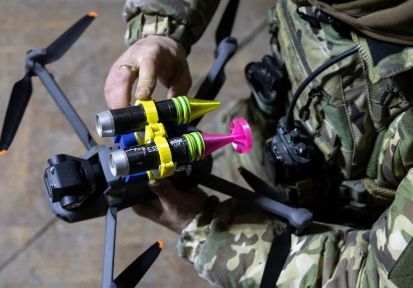
Drones: From Hobby Shop to Frontline Workhorse
Drones in Ukraine aren’t a novelty. They’re infrastructurelike roads, radios, and (unfortunately) sandbags. Both sides use them, but Ukraine has repeatedly shown a talent for turning off-the-shelf systems into battlefield tools, then scaling production through a mix of state programs and volunteer tech ecosystems.
FPV Drones and the “$500 Precision Strike” Problem
First-person-view (FPV) drones are the poster child of this war’s tactical revolution. Think small quadcopter, camera feed to goggles, pilot guiding it like a very angry video gameexcept the target is real and the consequences are permanent. With modifications and explosive payloads, FPVs can threaten vehicles, trenches, and exposed infantry at a fraction of the cost of traditional munitions.
The strategic implication is uncomfortable for any military that loves expensive hardware: when a relatively cheap drone can disable or destroy equipment worth hundreds of thousandsor millionsevery truck, radar, and parked vehicle becomes a potential liability if it’s visible and unprotected. This has pushed rapid changes in camouflage, decoys, electronic warfare, and short-range air defenseplus a never-ending battle against the sky itself.
Recon Drones: The Quiet Job That Wins Loud Fights
The most valuable drone mission is often not the dramatic boomit’s the quiet “I see you.” Commercial quadcopters and purpose-built reconnaissance UAVs help units confirm positions, find routes, and identify firing points. Recon drones also enable the modern version of counter-battery warfare: spot the artillery, triangulate the location, and respond before the enemy relocates.
This is where drones become less like individual gadgets and more like nodes in a network. A single drone feed might be useful. A system that fuses multiple feeds into a shared mapupdated constantlycan change the tempo of operations. Ukraine has pushed hard on this kind of shared situational awareness, creating faster targeting loops that can link drone operators, artillery crews, and commanders.
Long-Range Drones and Strikes Beyond the Front
Ukraine’s long-range drone strikes have also reshaped the war’s geography. If you can reach fuel depots, airfields, logistics hubs, and command facilities far from the frontline, you can force the enemy to defend more territory, disperse assets, and spend resources protecting the rear. Even when a strike doesn’t produce spectacular damage, it can still impose real costs: disrupted operations, paused flights, repositioned air defenses, and slower logistics.
Russia, for its part, has used mass drone and missile attacks against Ukrainian infrastructure, creating an ongoing defense-and-repair cycle. That reality makes communications and intelligence even more vital: when the grid and networks are under threat, you need redundancy, resilience, and a way to keep units connected.
Satellites: The High Ground Gets Crowded
Satellites have played roles in war for decades, but Ukraine has highlighted something newer: commercial space isn’t just supporting journalism or science anymoreit’s supporting battlefield awareness and operations. In plain English: there are more eyes in the sky, and many of them take credit cards.
Commercial Imagery Makes the Battlefield Harder to Hide
Before the full-scale invasion, commercial satellite imagery helped reveal Russian force buildups and made it difficult to keep large-scale preparations secret. During the war, imagery has supported everything from documenting damage to tracking equipment concentrations and assessing fortifications. This transparency changes behavior: big formations become riskier, static depots become tempting targets, and deception becomes more complicated (though still very possible).
The availability of commercial imagery also feeds the open-source intelligence (OSINT) ecosystem. Analysts outside the governmentthink research groups, journalists, and hobbyists with serious skillscan sometimes identify patterns that influence public understanding and even policy debates. That doesn’t replace classified intelligence, but it does create a wider “information battlefield” where facts can surface faster than propaganda can repaint them.
SAR Satellites: “It’s Cloudy” Is No Longer a Good Excuse
Optical imagery is powerful, but it has classic weaknesses: clouds, smoke, darkness. Synthetic aperture radar (SAR) helps solve that problem by imaging day or night and through many weather conditions. Ukraine’s access to SAR from commercial providers has been widely discussed as a meaningful advantage for monitoring movements and assessing damage when visibility is poor.
SAR doesn’t make war easyit just makes hiding harder. When the sky is gray and visibility is miserable, radar imaging can still provide clues about activity patterns, infrastructure changes, or concentrations of equipment. In a conflict where both sides often fight in harsh weather and smoky conditions, that matters.
Satellites for Communications: Starlink and the “Nervous System” of the Front
If satellites are the eyes, satellite internet is the nervous system. Ukraine’s use of satellite communicationsespecially Starlinkhas enabled frontline units to keep transmitting data, coordinating strikes, and operating drones even when terrestrial networks are damaged or jammed. It’s hard to overstate the impact of having relatively portable broadband in a war zone.
But the reliance cuts both ways. Outages and disruptions have shown how dependent modern operations can become on a single service. And reports that Russian forces have obtained and used Starlink terminalsdespite restrictionshave added another layer of complexity. In early 2026, reporting suggested new limits and verification measures reduced Russian battlefield access in some areas, affecting drone-enabled attacks and coordination.
The Kill Chain in 2026: Spot, Share, Strike, Verify
When people say “drones and satellites give Ukraine a chance,” they’re really describing a modern kill chain:
- Spot a target (satellite, drone, sensors, human observation).
- Share the information quickly (secure comms, mapping platforms, unit networks).
- Strike with the best available tool (FPV drone, artillery, loitering munition, missile, sabotage).
- Verify results (drone video, satellite imagery, follow-up reconnaissance).
Ukraine has invested heavily in digital situational awareness systems that help units see a shared picture of the battlefield. Analysts have pointed to Ukrainian platforms as real-world examples of how networked command-and-control concepts can function under pressureconnecting sensors and shooters in a way that speeds decisions.
Verification is also crucial. One of the quiet revolutions of this war is how quickly damage assessment can happen. Drone footage can confirm a hit within seconds. Satellite imagery can confirm broader effectslike whether a depot was destroyed, a bridge damaged, or an airfield impactedsoon after. That feedback loop improves targeting, reduces wasted munitions, and helps commanders adapt.
Cat-and-Mouse: Electronic Warfare, Jamming, and Adaptation
A drone war is also an electronic war. GPS signals can be jammed or spoofed. Drone links can be disrupted. Communications can be interfered with. Both sides constantly adjust frequencies, add shielding, harden systems, and invent workarounds. It’s innovation by necessityand necessity does not take weekends off.
Electronic Warfare: When the Air Is Full of Invisible Fists
Electronic warfare (EW) has become central to survival. If your drone loses navigation or your operator loses the video feed, your “precision strike” becomes a “precision crash.” That reality has pushed rapid experimentation: more autonomous functions, alternative navigation methods, signal hopping, and layered communications.
Space-based data can help here too. Some commercial providers track and map interference patterns, offering clues about where jamming is happening and how it shifts over time. It’s not magic; it’s intelligenceuseful, partial, and constantly contested.
Anti-Drone Defense: The Quest for a Cheap Shield
The drone threat creates a defense dilemma: you don’t want to spend a million-dollar missile on a thousand-dollar drone. That’s why both sides explore cheaper countersguns, electronic disruption, nets, decoys, and layered short-range defenses. Even helicopters and mobile gun platforms have been used to hunt drones in certain contexts.
The broader lesson is that air defense is being dragged downwardcloser to the ground, shorter in range, and more distributed. Instead of a few exquisite systems, forces increasingly need many smaller “shields” embedded with units.
Space Vulnerabilities and Political Risk
There’s another uncomfortable truth: commercial space services are not just technical assetsthey’re political and economic ones. Access can be shaped by contracts, national policy, corporate decisions, and alliance dynamics. Reporting in 2025 highlighted how pauses or restrictions on access to certain commercial imagery services could disrupt battlefield planning and targeting workflows.
That doesn’t mean satellites are unreliable. It means modern war inherits the messy reality of modern supply chains. When your comms and imagery are partly commercial, strategy includes not only tacticsbut agreements, redundancy plans, and alternatives.
What Comes Next: The Drone-Satellite Stack Becomes Standard
The innovations in Ukraine aren’t “special Ukraine tricks.” They’re previews. Militaries everywhere are studying how drones, satellites, and data fusion reshape conflictespecially for smaller states facing larger adversaries.
Scaling Production and Keeping Up with the Learning Curve
One of Ukraine’s most important achievements has been the scale of adaptation: turning lessons into procurement, procurement into training, and training into new tactics. Reports from research institutions have highlighted Ukraine’s push toward AI-enabled and autonomous systems as part of a broader effort to offset manpower and firepower disadvantages. The goal isn’t to replace soldiers with robots. It’s to reduce exposure, increase precision, and make limited resources hit harder.
Ethics, Dual-Use Tech, and the Civilian-Military Blur
This war also raises hard questions for the tech world. When consumer drones and commercial satellites become battlefield tools, the line between civilian and military infrastructure blurs. That can create new risks: companies become targets, supply chains become contested, and platforms designed for connectivity become enmeshed in conflict dynamics. Democracies will have to decide how to manage this reality without pretending the clock can be turned back.
The Bottom Line for Ukraine
Drones and satellites don’t guarantee victory. They don’t erase the horror of artillery, mines, and trench warfare. But they do give Ukraine something precious in a war of attrition: options. Options to see, options to strike, options to disrupt, and options to compensateat least partlyfor material disadvantages. In a conflict where time, information, and resilience matter as much as sheer mass, that chance is realand it’s changing how the world understands modern war.
Field Notes: Experiences From the Drone-and-Satellite War (Reported, Not Romanticized)
The phrase “drones and satellites” can sound abstractlike something discussed in clean conference rooms with coffee that costs too much. On the ground, it’s less abstract and more like living inside a permanent group chat where the stakes are life and death, and the notifications never stop. The following experiences are composites drawn from reported accounts of how this tech-enabled fight feels for the people using it.
1) The drone pilot’s world is a rectangle of video. A lot of frontline drone work is staring at a screen until your eyes feel like they’ve been replaced with sandpaper. The pilot watches a grainy feed: a tree line, a road, a field that looks exactly like the last fielduntil it doesn’t. A truck appears for three seconds, then vanishes behind cover. That tiny moment triggers a chain: a message to a unit, a pin on a digital map, a decision about whether to strike now or wait. The pilot’s hands might be steady, but their brain is sprintingmeasuring battery life, signal strength, wind, and the nagging fear of electronic jamming. And when an FPV strike is launched, the intensity spikes: the target grows in the frame, the drone dips, the image jitters, and the last clear picture might be a vehicle’s hood ornament before the feed goes white. Thenimmediatelyanother drone is prepped, because the battlefield doesn’t pause for processing emotions.
2) The satellite analyst’s experience is patience mixed with urgency. Satellite data is powerful, but it’s not always instant gratification. Sometimes it’s a fresh image that confirms a depot was hit. Sometimes it’s waiting for a pass, comparing changes over days, and spotting the small details: new tire tracks, disturbed earth, equipment rearranged, a bridge that looks “different” in a way that matters. The job is part detective work, part logistics, part “please let the clouds move.” For analysts supporting operations, the pressure comes from knowing that a single confirmationor a single missed cluecan change decisions that affect people in minutes, not months. In this war, satellites don’t just document history; they can help shape the next hour.
3) The commander’s experience is living inside the targeting loop. A commander might receive a drone clip, a map update, and a message from an adjacent unit within the same breath. The challenge isn’t a lack of informationit’s the need to filter it fast, decide fast, and communicate fast. When networks work, the battlefield feels “connected”: units share sightings, coordinate fires, and adjust quickly. When networks faildue to strikes, outages, or jammingthe war feels older and more dangerous. Orders slow down. Drones fly without reliable feeds. Artillery becomes less precise. Uncertainty creeps back in. That’s why redundancy becomes a lived experience, not a doctrine word: paper maps, alternative radios, pre-planned signals, backup power, and multiple comms paths.
Across these perspectives, one theme repeats: adaptation is constant. Operators learn new frequencies, new flight paths, new counter-jam tricks. Analysts learn new tools and faster workflows. Commanders learn to treat connectivity and surveillance as “combat supplies” just as real as fuel and ammunition. It’s exhausting, it’s technical, and it’s intensely humanbecause behind every drone feed and satellite image, someone is trying to keep people alive and make scarce resources matter.
And maybe the strangest experience of all is this: the war is both hyper-modern and painfully old. Soldiers still dig trenches and fight over treelines. But above them, the sky is crowded with buzzing rotors and orbiting sensorsreminding everyone that the future arrived early, and it arrived loudly.
Conclusion
The Russo-Ukrainian War has shown that a smaller force can gain meaningful leverage when it can see, communicate, and strike with speedand when it can keep innovating under pressure. Drones and satellites don’t replace courage, strategy, or endurance. But they can tilt outcomes at the margins, and in a grinding war, margins add up. Ukraine’s experience is already shaping military thinking worldwide: the next major conflict will not just be fought with steel and explosives, but with data, networks, and thousands of cheap machines that turn visibility into vulnerability.