Table of Contents >> Show >> Hide
- Why Typhoon Jebi Became One of 2018’s Most Watched Storms
- What the Photos From Space Actually Showed
- When Jebi Reached Japan, the Ground Story Caught Up With the Space Story
- Why the “From Space” Angle Matters More Than You Might Think
- The Bigger Lesson From Typhoon Jebi
- Experience: What It Feels Like to Follow a Typhoon From Space
- Conclusion
- SEO Tags
Some weather stories arrive with a drizzle of headlines. Typhoon Jebi arrived like a giant spinning warning label pasted over the western Pacific. In late August and early September 2018, satellites watched the storm grow from an organized tropical system into a fierce typhoon with a sharply defined eye and the kind of symmetry that makes meteorologists stare, point, and say the professional version of “well, that’s not ideal.” By the time Jebi headed toward Japan, the images from space were already telling a story of speed, structure, and menace.
That is what made the 2018 Japan typhoon coverage so unforgettable. The storm was not only destructive on the ground; it was visually dramatic from orbit. NASA and NOAA imagery, Himawari views, and other satellite products captured Jebi in true color, infrared, rainfall estimates, and nighttime data. Those images did more than look impressive. They helped explain why the storm intensified so quickly, why forecasters were worried, and why western Japan braced for serious disruption. If you want to understand Typhoon Jebi, the photos from space are not just decoration. They are the map, the warning, and part of the evidence.
Why Typhoon Jebi Became One of 2018’s Most Watched Storms
Typhoon Jebi earned attention because it looked powerful before it even reached Japan. Satellite views in the northwest Pacific showed a compact but intense cyclone with a clean eye and tightly wrapped bands. In plain English, it looked like the atmosphere had decided to draw a perfect spiral and then give it teeth. NASA imagery taken near the Northern Mariana Islands showed Jebi with a small eye and a striking curved structure, while forecasting discussions noted warm ocean water and low wind shear that favored strengthening. That combination is basically weather’s version of “all systems go.”
By the end of August 2018, Jebi had intensified into a super typhoon over the open Pacific. The storm’s appearance from space became part of the story because its cloud shield was so organized and its eye so distinct. Scientists and weather analysts pay close attention to those visual clues. A well-defined eye, a symmetric eyewall, and deep convection wrapped around the center can signal a strong and efficient tropical cyclone. Jebi checked those boxes with unnerving style.
As the typhoon curved toward Japan, it carried not just wind and rain, but a visual identity. Unlike a blurry blob on a forecast map, Jebi was a storm you could actually see developing frame by frame. That matters for public understanding. A storm with a clear eye in satellite imagery suddenly feels less abstract. It is not just a weather bulletin. It is a giant rotating machine aimed at land.
What the Photos From Space Actually Showed
1. A Beautifully Terrifying Eye
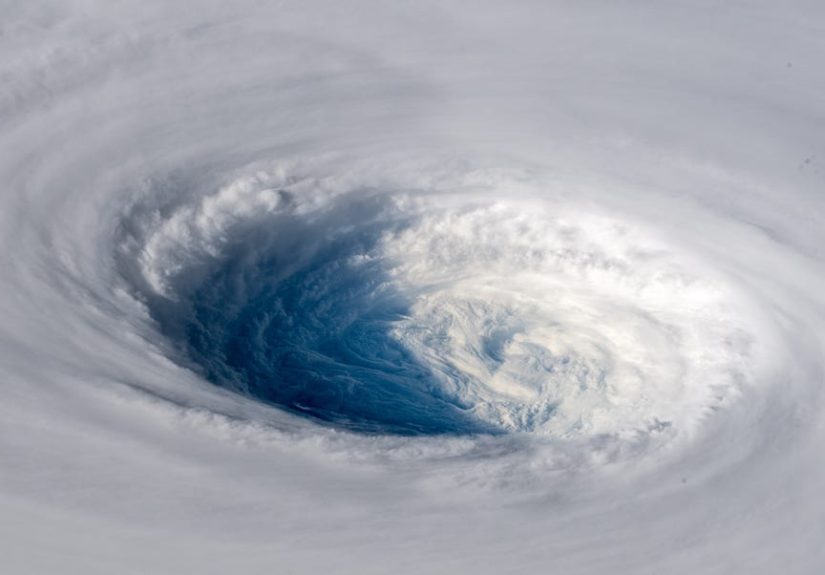
One reason “Japan Typhoon 2018” became such a searchable topic is simple: the pictures were stunning. NASA’s Earthdata archive later highlighted a September 3, 2018 image of Super Typhoon Jebi approaching Japan, captured by the VIIRS instrument aboard the joint NASA/NOAA Suomi NPP satellite. It showed a classic cyclone form: dense cloud shield, curved outer bands, and a crisp eye that looked almost too neat for comfort.
That kind of image is the meteorological equivalent of seeing a shark fin in crystal-clear water. It is impressive, yes, but it also announces danger with almost rude clarity. The eye signaled a highly organized storm, and the clean spiral suggested strong circulation. Even without reading a single forecast discussion, a viewer could tell this was not a sleepy tropical system muddling around offshore.
2. Rapid Intensification in Motion
Satellite analysis from the University of Wisconsin’s CIMSS showed Jebi undergoing very rapid intensification on August 30, 2018. Himawari-8 infrared imagery revealed a nearly symmetric eyewall and an annular appearance, while visible imagery showed fine details inside the eye, including mesovortices. If that sounds technical, here is the simpler takeaway: the storm was not just strong; it was structurally elegant in the way powerful storms often are, and the satellites were good enough to catch the fine print.
Those details matter because rapid intensification is one of the trickiest parts of tropical cyclone forecasting. A storm that strengthens quickly can outpace public expectations. When space-based instruments show colder cloud tops, tighter structure, and a better-defined eye, forecasters gain clues that the system is becoming more intense. Jebi’s satellite story was basically a masterclass in why orbital observation matters.
3. Rainfall, Not Just Wind
Typhoons are not one-trick disasters. The dramatic spiral is only part of the problem. NASA’s Global Precipitation Measurement coverage showed that Jebi brought broad swaths of heavy rain over Japan and nearby waters, with accumulated estimates of 100 millimeters or more across large areas during the period around landfall. Meanwhile, the storm was moving into a region that had already seen severe weather that summer. In other words, the atmosphere was not arriving at a fresh white carpet. It was stomping into a room that already looked exhausted.
Satellite rainfall products help explain why impacts can spread well beyond the eye. Heavy bands, feeder lines, and preexisting frontal systems can combine to produce flooding risks across wide regions. So when people searched for “photos of the typhoon headed for Japan taken from space,” they were not just looking at pretty swirls. They were looking at a system with the power to reshape coastlines, flood infrastructure, and overwhelm transport networks.
4. Aftermath Seen From Orbit
One of the most striking post-storm images came after the clouds began to clear. NASA Earth Observatory published imagery of Osaka Bay and the Kansai region showing brown plumes of suspended sediment pouring from river mouths into coastal waters. It was a reminder that satellite imagery does not stop being useful when the eyewall moves on. After landfall, space-based views can reveal flooding patterns, sediment transport, coastal runoff, and other environmental changes that are difficult to understand from street level alone.
There is something sobering about those aftermath images. Before landfall, the storm looks clean and geometric, almost like a textbook diagram. After landfall, the evidence becomes messy: muddy water, damaged infrastructure, scarred coastlines, and disrupted communities. Space photography lets us watch that transition from elegant spiral to real-world consequences.
When Jebi Reached Japan, the Ground Story Caught Up With the Space Story
Once Typhoon Jebi hit western Japan in early September 2018, the scale of disruption matched the drama seen from orbit. Reports described it as the strongest typhoon to make landfall in Japan since 1993. Airports, rail lines, roads, utilities, and coastal areas all took hits. Kansai International Airport, built on an artificial island in Osaka Bay, became one of the defining symbols of the event after floodwater inundated parts of the facility and a tanker drifted into the bridge connecting the airport to the mainland.
That image alone felt almost surreal, like a disaster movie pitched by someone who had clearly had too much coffee: a flooded offshore airport, thousands stranded, a damaged bridge, travel systems in chaos. Yet it was real, and that is partly why the 2018 Japan typhoon remains such a memorable weather event. Jebi disrupted daily life at a scale that was easy to grasp even for people half a world away.
Western Japan also saw widespread power outages, hundreds of canceled flights, transport shutdowns, and serious damage to homes, businesses, and historic sites. The human cost was sobering, with deaths and injuries reported as the storm crossed the region. For all the beauty of the satellite imagery, the ground impacts were a blunt reminder that the most photogenic storms are often the least polite.
Why the “From Space” Angle Matters More Than You Might Think
Space Photos Make Scale Understandable
Weather forecasts can be full of numbers: wind speed, central pressure, rainfall totals, storm track, and timing. Those matter, but numbers do not always create instant understanding. A satellite image can do that in seconds. With Jebi, viewers could see the storm’s size, organization, and trajectory. The imagery gave shape to risk. Instead of hearing “a strong typhoon is approaching,” people could see a massive atmospheric engine coiling toward Japan.
Satellites Help Forecasters See Day and Night
Another reason the Typhoon Jebi imagery stood out is that multiple instruments captured different aspects of the storm. True-color views showed the cloud structure in daylight. Infrared imagery revealed cloud-top temperatures and organization. Day/Night Band imagery provided detailed views even when the sun was down. Microwave and rain-rate products helped expose the precipitation core and feeder bands. One storm, many lenses.
That is what modern weather observation does so well. It does not rely on one dramatic photo. It builds a layered understanding. A visible image might show a textbook eye. Infrared might reveal intense convection. Rainfall estimates might show the hydrological threat. Post-event imagery might show runoff and damage patterns. The result is less like a single snapshot and more like a full documentary assembled from orbit.
They Also Shape Public Memory
There is a reason certain storms stay in public memory while others blur together. Visual identity matters. Jebi’s photos from space gave the storm a face, and that face was unforgettable: circular, bright, sharply defined, and moving with quiet confidence toward a densely populated country. Even years later, many people remember not just the airport flooding or the travel chaos, but the sight of the storm itself.
In that sense, satellite images do cultural work as well as scientific work. They become part of how an event is remembered, shared, archived, and searched online. The keyword “Japan Typhoon 2018” is not only about damage reports. It is also about those mesmerizing images that made the storm feel visible before it was personal.
The Bigger Lesson From Typhoon Jebi
Typhoon Jebi was a reminder that modern storm coverage happens on two levels at once. On the ground, there are evacuations, disrupted travel, damaged property, and emergency response. In space, there is a steady stream of imagery turning atmospheric motion into readable evidence. The two stories are connected. Without satellite data, the forecast picture is weaker. Without ground impacts, the images risk becoming just another dramatic wallpaper for weather enthusiasts.
Jebi showed how quickly a storm can evolve, how vulnerable major infrastructure can be, and how important remote sensing has become for both forecasting and storytelling. The images captured by NASA, NOAA, and related observing systems did not just make the typhoon look huge. They helped explain why it was huge news.
And maybe that is the strangest thing about great satellite photography: it makes the planet feel both majestic and fragile at the same time. From orbit, Jebi looked elegant. From the ground, it was costly, chaotic, and dangerous. Both views were true. Together, they tell the full story.
Experience: What It Feels Like to Follow a Typhoon From Space
Watching a typhoon from space is a strange emotional experience because the first feeling is often awe, not fear. You look at the image and think, “That is incredible.” The swirl is perfect. The eye is neat. The cloud bands look painted by a patient hand. There is a temptation to admire the symmetry the way you would admire a galaxy photo or a beautiful piece of abstract art. For a few seconds, the storm seems almost detached from human life. It is just weather being dramatic in the open Pacific, performing for the cameras like it knows it has good lighting.
Then the map sinks in. Japan is in the frame. The coastline is not far away. The storm is not posing. It is moving. That is when admiration turns into a different kind of attention. Every update feels heavier. A sharper eye does not mean better news. Tighter cloud bands do not mean a prettier postcard. They mean the system is organized, dangerous, and likely to hit somewhere people live, work, travel, and try to have perfectly normal Tuesdays.
Following Typhoon Jebi in satellite imagery makes you appreciate how modern weather awareness works. Decades ago, many people would have known a storm was coming mostly through radio bulletins, barometers, and local forecasts. In 2018, the public could see the storm hours and days before landfall in astonishing detail. You could watch it intensify, curve, and approach. That kind of visibility changes your relationship to risk. The storm stops being a rumor and becomes a visible fact.
There is also something deeply humbling about realizing how small major human systems look next to one powerful cyclone. Airports, bridges, ports, train lines, and cities can dominate everyday life. They feel permanent, engineered, and under control. But when you watch a typhoon approaching from orbit, all of that confidence starts to shrink. The storm does not care about flight schedules, tourist plans, commuter routines, or your very organized to-do list. It arrives with its own priorities, and those priorities are wind, water, and momentum.
The most memorable part of the Jebi imagery is not just the storm itself, but the transition from anticipation to aftermath. Before landfall, the photos feel cinematic. After landfall, the images become forensic. Brown water pours into the bay. Infrastructure looks wounded. The picture is less about meteorological beauty and more about consequence. That shift is important. It reminds us that the purpose of satellite imagery is not only to inspire wonder. It is also to improve warning, sharpen response, and document what happened.
In the end, following Typhoon Jebi from space leaves you with a layered memory: admiration for the science, respect for the forecasters, and concern for the people in the storm’s path. It is one thing to read that a typhoon is headed toward Japan. It is another to watch the giant spiral tighten over the ocean and know that every elegant curve in the cloud field may soon become a flooded road, a delayed rescue, a darkened neighborhood, or a very long night for someone waiting it out indoors. That is why these images stay with people. They are beautiful, yes, but they are also warnings written in cloud.
Conclusion
Typhoon Jebi was one of the most visually striking and operationally significant storms of 2018. The photos of the typhoon headed for Japan taken from space helped transform a complicated weather event into something instantly understandable. They showed the storm’s structure, hinted at its strength, and later documented the aftermath around Osaka Bay and the Kansai region. More importantly, they revealed how modern satellite technology turns distant orbit into practical awareness on the ground.
That is why the phrase “Japan Typhoon 2018” still carries weight. It points not only to a severe storm, but to one of those moments when science, imagery, and public attention all lined up. Jebi looked enormous because it was. It looked organized because it was. And the photos mattered because they helped the world see the risk before, during, and after landfall. Sometimes the clearest warning comes from hundreds of miles above Earth, delivered in the shape of a perfect spiral no one should underestimate.