Table of Contents >> Show >> Hide
- What Makes a Cloud “Rare” Anyway?
- 1. Asperitas: The Upside-Down Stormy Sea
- 2. Noctilucent Clouds: Night-Shining Ghosts at the Edge of Space
- 3. Nacreous Clouds: Polar Mother-of-Pearl
- 4. Mammatus Clouds: The Bubble-Wrap Underside of a Storm
- 5. Lenticular Clouds: The UFO Impostors
- 6. Roll Clouds and the Morning Glory
- 7. Kelvin–Helmholtz Clouds: Waves About to Break
- 8. Hole-Punch (Fallstreak) Clouds
- 9. Undulatus Wave Clouds
- 10. Rarer Iridescent Veils and “Fire Rainbows”
- Real-World Experiences: Living with a Rare-Cloud Obsession
- Conclusion
Look up for a second. The sky might look like the same old blue ceiling with a few fluffy
cotton balls, but every now and then it goes completely off-script. Waves, glowing curtains,
UFO pancakes, giant bubble-wrap skies – rare cloud formations are nature’s way of reminding
us she has a wild imagination and absolutely no need for Photoshop.
This list dives into 10 of the most amazing rare cloud formations, explains the science
behind each one, and offers tips on how to spot and photograph them. Think of it as a
Listverse-style deep dive for sky nerds, weather geeks, and anyone who has ever almost
walked into a streetlight while staring at the clouds.
What Makes a Cloud “Rare” Anyway?
Most clouds fall into familiar categories like cumulus, stratus, and cirrus. Meteorologists
classify them by height, shape, and structure, using a system formalized by the World
Meteorological Organization’s International Cloud Atlas.
Rare clouds still fit into that system, but they show unusual features, extreme conditions,
or special optical effects that only happen when the atmosphere is just right – often in
very specific locations or seasons.
In other words, you can’t order them on demand. You’re lucky if you see even a few of these
in your lifetime, and luckier still if you have your camera pointed in the right direction
when they show up.
1. Asperitas: The Upside-Down Stormy Sea
How it looks
Asperitas (formerly nicknamed undulatus asperatus) looks like someone turned the
ocean upside down and glued it to the sky. Dark, wavy, churning textures spread across the
cloud base, giving the impression of looking up into a rolling, turbulent sea. It’s dramatic,
eerie, and absolutely made for moody Instagram captions.
How it forms
Asperitas usually appears beneath widespread layers of mid-level clouds, often following or
near decaying thunderstorms. The chaotic wave patterns are thought to be caused by
atmospheric gravity waves – ripples of energy moving through layers of air with different
densities and winds.
Why it’s special
Asperitas is the first new cloud species formally added to the International Cloud
Atlas in decades, recognized in 2017 after years of documentation by the Cloud Appreciation
Society and meteorologists.
That makes it the “new kid” in official cloud science – and one of the rarest large-scale
displays you can see, especially over the plains and Midwest in the United States.
2. Noctilucent Clouds: Night-Shining Ghosts at the Edge of Space
How they look
Noctilucent clouds glow with an electric blue or silver light against the deep twilight sky.
They appear as delicate, rippled veils or fine, braided strands low over the horizon, usually
in the northwest or north about 30–90 minutes after sunset in late spring and summer at high
latitudes.
How they form
These clouds float at around 80 kilometers (about 50 miles) up – the highest clouds in
Earth’s atmosphere, near the edge of space. Tiny ice crystals form on microscopic dust
particles in the extremely cold upper mesosphere, then catch sunlight long after the ground
below is in darkness, causing that otherworldly glow.
Why they’re special
Noctilucent clouds were first reported in the late 19th century, and some scientists think
their increasing frequency may be linked to changes in the upper atmosphere, including water
vapor supplied by methane and possibly human activity. Whatever the cause, seeing them feels
like getting a private aurora-style light show courtesy of the mesosphere.
3. Nacreous Clouds: Polar Mother-of-Pearl
How they look
Nacreous clouds, also known as polar stratospheric clouds, shimmer with intense pastel
colors – pinks, greens, blues, and golds – that look like oil on water or the inside of a
seashell. They often appear just after sunset or before dawn, glowing high above darker
lower clouds.
How they form
These clouds form in the lower stratosphere, around 15–25 kilometers (9–16 miles) above
Earth, in extremely cold polar winter conditions. Tiny ice or nitric acid particles diffract
sunlight, creating iridescent colors much stronger than the subtle hues of more common
irisation.
The dark side
They’re stunning, but they’re also chemically important: some types of polar stratospheric
clouds provide surfaces for reactions that destroy ozone, helping trigger the infamous
“ozone hole” over Antarctica.
4. Mammatus Clouds: The Bubble-Wrap Underside of a Storm
How they look
Mammatus clouds resemble a sky full of soft, puffy pouches or bubbles hanging from the base
of a cloud layer – usually anvil-shaped thunderstorm clouds. Think bubble wrap, but on a
terrifying, apocalyptic scale.
How they form
They are associated with sinking pockets of colder, denser air within a thunderstorm’s
anvil. As these blobs of air descend, they drag cloud material downwards, creating the
distinctive pouch-like structures. They’re often seen after severe thunderstorms, when the
worst of the weather is moving away but the atmosphere is still extremely turbulent.
Should you panic?
Mammatus often appear near severe weather, but by the time you see them clearly overhead,
the most dangerous part of the storm is usually already past. Still, they’re a good reminder
that the atmosphere just did something powerful.
5. Lenticular Clouds: The UFO Impostors
How they look
Lenticular clouds (from the Latin for “lens-shaped”) are smooth, layered, oval clouds that
often stack on top of each other like a pile of pancakes or a flying saucer parked over a
mountain range. If someone posts a “UFO” photo online, there’s a decent chance they actually
caught a lenticular.
How they form
When stable, moist air flows over mountains, it can set up stationary waves downwind. At
certain points in these waves, air rises, cools, and condenses into cloud. The result is a
stationary, sharply defined cloud that hovers in place while air flows through it – like a
standing wave sculpted out of water vapor.
Fun fact for travelers
Pilots know lenticulars can signal strong turbulence nearby, so if you spot them from a
plane window, maybe tighten your seatbelt before you reach for your phone.
6. Roll Clouds and the Morning Glory
How they look
Roll clouds are long, tube-shaped clouds that stretch across the sky like a giant horizontal
cylinder. Seen from below, they can look like a vast white wall rolling silently overhead.
How they form
They’re a type of arcus cloud typically formed along gust fronts or boundaries where cool
air undercuts warm air. Warm moist air is lifted, cools, and condenses, forming a tube-like
band that may appear to “roll” as air circulates around it.
Why Australia gets the deluxe version
The most famous example is the Morning Glory cloud over northern Australia’s Gulf of
Carpentaria and Cape York. Under just the right conditions in the dry season, enormous roll
clouds up to hundreds of miles long sweep through at low levels – a bucket-list event for
glider pilots and cloud photographers.
7. Kelvin–Helmholtz Clouds: Waves About to Break
How they look
Kelvin–Helmholtz clouds look like a row of ocean waves frozen mid-crest along the top of a
cloud layer. Each crest curls over like a surfable wave, repeating along the horizon in a
neat, wavelike pattern – basically the sky doing impressionist seascape art.
How they form
These clouds occur where two layers of air slide past each other at different speeds, with a
sharp boundary between them. That velocity difference creates shear instability, causing the
upper edge of the lower cloud layer to ripple and curl over, just like breaking waves on the
ocean.
Where you might see them
Kelvin–Helmholtz formations are fleeting and usually small in scale, making them rare to
spot and even rarer to photograph. If you do catch them, don’t blink – they can disappear
within minutes as the airflow changes.
8. Hole-Punch (Fallstreak) Clouds
How they look
Hole-punch clouds look as if someone punched a clean circular or oval gap in an otherwise
solid sheet of mid-level cloud. Sometimes wispy streaks of precipitation fall from the
center, giving a dramatic, halo-like effect.
How they form
These occur in altocumulus or cirrocumulus layers composed of supercooled liquid droplets –
water that is below freezing but still liquid. When something – often an airplane passing
through – triggers ice crystals to form, the crystals grow rapidly at the expense of the
droplets, clearing out a hole and causing streaks of falling ice (a fallstreak).
From mystery to science
Before their physics was understood, hole-punch clouds inspired plenty of conspiracy theories
and “portal in the sky” headlines. Now we know they’re a gorgeous but perfectly natural
side-effect of phase changes in supercooled clouds – with a little help from modern aviation.
9. Undulatus Wave Clouds
How they look
Undulatus refers to cloud layers that appear rippled or banded, often covering the sky with
gentle waves or corrugations. While some undulating patterns are common, especially in
altostratus or stratocumulus, particularly pronounced or large-scale wave fields can be
spectacular and rare.
How they form
Atmospheric gravity waves – oscillations triggered by mountains, frontal boundaries, or
strong jet-stream winds – cause layers of air to rise and sink. Where the air rises, clouds
form; where it sinks, they thin or vanish. The result is a sky-wide fingerprint of parallel
bands or waves. Asperitas is essentially an extreme, turbulent cousin of these more orderly
undulations.
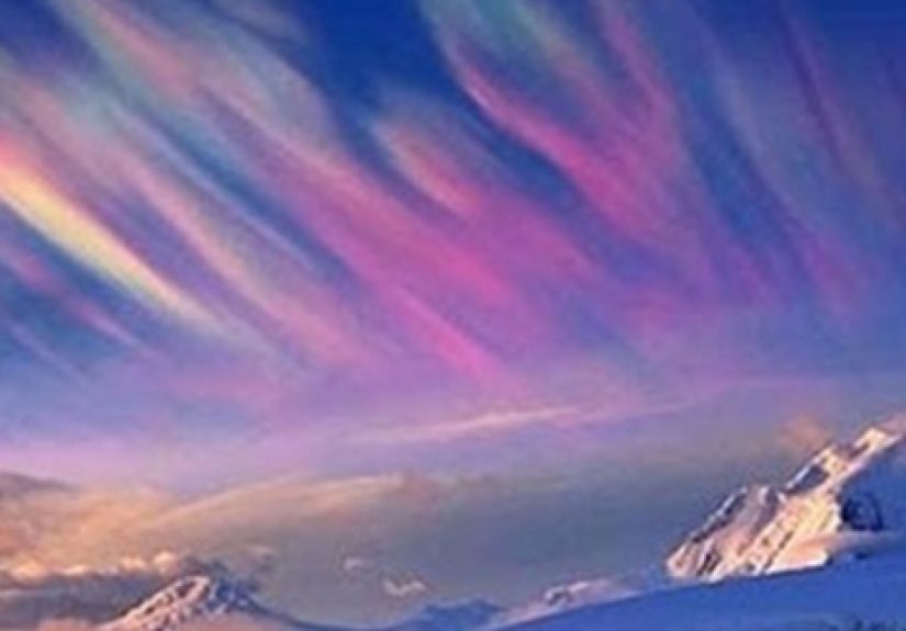
10. Rarer Iridescent Veils and “Fire Rainbows”
How they look
Sometimes thin clouds near the sun glow with subtle rainbow colors – soft bands of pink,
green, and blue shimmering at the edges of clouds. In even rarer cases, bright spectrum-like
arcs appear high in cirrus clouds, popularly nicknamed “fire rainbows” (though they’re
neither fire nor rain).
How they form
Classic cloud iridescence is caused by diffraction of sunlight around tiny, uniformly sized
droplets or ice crystals in thin clouds. More dramatic circumhorizontal arcs – the so-called
“fire rainbows” – occur when sunlight passes through hexagonal plate ice crystals at just
the right angle, usually in high cirrus clouds when the sun is very high in the sky.
Why you rarely see them
These displays require precise geometry and very specific crystal orientations. They’re also
easy to miss in bright daylight unless you shade the sun with a building, tree, or your own
hand (while protecting your eyes, obviously).
Real-World Experiences: Living with a Rare-Cloud Obsession
Once you learn about rare cloud formations, everyday commutes become low-budget sky safaris.
The good news: you don’t need a PhD in meteorology to enjoy them. You just need curiosity,
a bit of pattern recognition, and the willingness to look up at weird times.
Many skywatchers say their cloud obsession started with a single “what on earth is THAT?”
moment. Maybe it was seeing mammatus glowing orange at sunset after a severe storm, or
catching a suspiciously UFO-like lenticular cloud parked over a mountain. Those experiences
stick because they feel personal: the entire atmosphere briefly rearranges itself into
something strange, and you just happened to be there.
One practical tip is to pair cloud watching with habits you already have. Step outside with
your coffee in the morning and scan the horizon. Check the sky again after storms pass, when
mammatus and asperitas are most likely to show. If you live at higher latitudes, build a
“twilight check” into late spring and early summer evenings – a quick look toward the
northern or western horizon 30–60 minutes after sunset might reward you with noctilucent
clouds glowing while everything else is dark.
Another strategy is to use weather patterns to your advantage. Lenticular clouds favor windy
days downwind of mountains. Morning Glory roll clouds are most consistent along very specific
coastal regions. Noctilucent clouds have a seasonal “window.” Paying attention to local
forecasts and patterns doesn’t guarantee a show, but it nudges the odds in your favor.
Photography adds a whole new layer of fun. Rare clouds are large, high-contrast subjects, so
even a decent smartphone can capture them well. Wide-angle lenses help you show scale – a
roll cloud stretching from one horizon to the other, or mammatus pouches filling the entire
sky. Including foreground elements like trees, skylines, mountains, or water gives viewers a
sense of size and place. For glowing phenomena like noctilucent or nacreous clouds, a tripod
and longer exposure let you bring out color and detail your eyes barely register.
Of course, there’s a safety disclaimer hiding in those pretty pictures. Some of the best
displays occur around strong storms, cold fronts, and gusty winds. If you’re chasing clouds,
treat thunder, lightning, and severe weather with respect. Mammatus beneath a retreating
storm might be perfectly fine to enjoy from a safe spot, but don’t drive into active severe
weather just to get a dramatic shot. The cloud will not be impressed.
One underrated benefit of rare-cloud hunting is how it changes your relationship with “bad”
weather. Instead of seeing clouds as something that ruins a sunny day, you start seeing them
as clues – signs of invisible motions and structures in the atmosphere. A dull gray sky
becomes a potential canvas for iridescence. A ragged storm anvil becomes a possible stage for
mammatus or asperitas. Even if nothing unusual appears, the act of paying attention turns a
routine day into a small adventure.
And finally, there’s the social side. Share your photos, but also share the names and stories
behind these formations. Telling someone, “That’s not a UFO, that’s a lenticular cloud caused
by mountain waves,” or, “Those glowing bands are noctilucent clouds way up near the edge of
space,” is a tiny act of science communication. You’re not just posting pretty pictures –
you’re helping people see the sky as a living, dynamic system instead of a static backdrop.
So keep your eyes open. Most days will be ordinary, but every so often the atmosphere will
roll out something spectacular – a upside-down ocean, a glowing curtain at midnight, or a
perfect circular “hole” punched out of the clouds. When that happens, you’ll know exactly
what you’re looking at… and you’ll be very glad your camera battery is charged.
Conclusion
Rare cloud formations are the atmospheric equivalent of bonus levels in a video game:
unexpected, visually stunning, and deeply satisfying if you know how to unlock them. From
newly recognized asperitas to ghostly noctilucent clouds and iridescent polar veils, each
of these formations tells a story about wind, temperature, moisture, and light interacting in
just the right way.
You don’t need special equipment, just attention – and maybe a little patience. The next time
the sky looks “off,” don’t dismiss it. Grab your phone, step outside, and take a second look.
You might discover that the most spectacular natural wonders aren’t in faraway national parks
or exotic destinations – they’re floating quietly above your own backyard.