Table of Contents >> Show >> Hide
- Why Geospatial Scanning Was the Perfect Jubilee Sidekick
- The Five London Landmarks and What the Scans Revealed
- 1. Buckingham Palace: Ceremony, Symmetry, and the Power of the Public Face
- 2. St Paul’s Cathedral: A Dome That Still Knows How to Steal the Scene
- 3. Tower of London: From Fortress to Point Cloud Without Losing an Ounce of Drama
- 4. Tower Bridge: Proof That Infrastructure Can Have Main-Character Energy
- 5. Trafalgar Square: The Civic Stage Gets a Digital Encore
- What the Results Really Mean
- Experiences From Exploring the Topic: What Stayed With Us Most
- Final Takeaway
Some anniversaries get a cake. Some get fireworks. Queen Elizabeth II’s Platinum Jubilee got a full-blown weekend of pageantry, concerts, services, and enough red-white-and-blue energy to make even the London pigeons look patriotic. But tucked into that celebratory moment was something far geekier and, honestly, far cooler: geospatial scanning technology was used to digitally recreate five of London’s most recognizable landmarks in 3D.
Now, before anyone imagines a sci-fi ray gun zapping Buckingham Palace into the metaverse, let’s keep both feet on the cobblestones. The project used LiDAR-based mobile scanning and point-cloud visualization to capture the geometry of real places with astonishing speed. The result was not just a flashy tribute for the Jubilee. It was a reminder that some of the oldest symbols of monarchy, faith, engineering, and civic life can now be explored through some of the newest tools in mapping and spatial technology.
That mix is what makes this story so irresistible. On one side, you have royal history, stone facades, domes, towers, bridges, and public squares loaded with symbolism. On the other, you have geospatial workflows, digital twins, scan-to-model thinking, and the growing idea that heritage should not only be photographed and admired, but measured, preserved, and experienced in three dimensions.
So what happened when these two worlds met for the Queen’s Platinum Jubilee? In a word: perspective. The scans did not replace the landmarks. They revealed them differently. They turned familiar postcard icons into layered spatial stories, exposing shape, scale, circulation, symmetry, and engineering logic in ways ordinary sightseeing rarely can.
Why Geospatial Scanning Was the Perfect Jubilee Sidekick
The Queen’s Platinum Jubilee marked 70 years on the throne, the first time a British monarch had reached that milestone. That made London itself part of the celebration. Buckingham Palace stood at the center of the public spectacle. St Paul’s Cathedral hosted the Service of Thanksgiving. The Tower of London leaned into Jubilee season with Superbloom in the moat. Trafalgar Square remained what it always is in big national moments: a stage set for public feeling. Tower Bridge, meanwhile, continued doing what Tower Bridge does best, which is making Victorian infrastructure look annoyingly photogenic from every angle.
Geospatial scanning fit that moment beautifully because it treats landmarks as both symbols and spatial objects. LiDAR works by sending out pulses of light and measuring the returns, creating dense point-cloud data that can be turned into accurate three-dimensional models. In broader geospatial practice, those models can support surveying, mapping, analysis, design coordination, and digital twin workflows. For historic assets, the value is especially obvious. A measured 3D record captures form, proportion, surface relationships, and structural character in a way flat photography simply cannot.
That is why scan-based documentation has become such a big deal in preservation circles. Around the world, digital capture is increasingly used to document museums, threatened heritage sites, and major historic structures. It can support restoration, public education, virtual access, and long-term conservation planning. Put more simply: when you scan a landmark well, you are not just making cool visuals. You are creating a usable spatial memory.
And for a Jubilee rooted in continuity, duty, and history, that feels oddly poetic. Monarchies talk constantly about legacy. Geospatial scanning gives legacy coordinates.
The Five London Landmarks and What the Scans Revealed
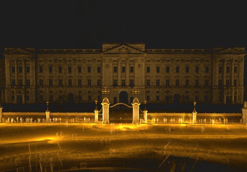
1. Buckingham Palace: Ceremony, Symmetry, and the Power of the Public Face
Buckingham Palace was always going to be the headline act. The Platinum Party at the Palace was staged in front of it, and the building’s East Wing contains the famous central balcony that has become shorthand for royal visibility itself. The balcony was introduced in the 19th century, and generations of royal appearances have turned that stretch of facade into one of the most recognizable architectural frames in the world.
In the scan project, Buckingham Palace’s grand entrance was captured in about 23 minutes. That alone is a delightful little flex. A place built to project permanence was documented in less time than it takes many people to pick a filter for their vacation photos.
What makes the Palace so compelling in 3D is not just its fame. It is the balance of monumentality and choreography. The facade is all about proportion, rhythm, repetition, and controlled spectacle. In a scan, those qualities become measurable instead of merely decorative. The Palace stops being just “the place where the royals wave” and becomes a spatial study in how architecture stages authority for a crowd.
That matters because Buckingham Palace is not only a residence. It is a performance surface for national ritual. The point cloud brings out that public-facing function with surprising clarity. You notice the depth of the frontage, the alignment of the entrance zone, the disciplined geometry that lets thousands of people read one building as a symbol. The scan does not make it less majestic. It shows how carefully the majesty is engineered.
2. St Paul’s Cathedral: A Dome That Still Knows How to Steal the Scene
St Paul’s Cathedral is one of those buildings that can make modern London look as though it politely agreed to stay out of the way. Designed by Sir Christopher Wren in the late 17th century, it remains one of the defining elements of the skyline, and during the Platinum Jubilee it hosted the Service of Thanksgiving for the Queen’s reign.
The scan reportedly took about 19 minutes, capturing the cathedral’s columns, sweeping structure, and iconic dome. That dome is not just decorative frosting. It is the whole drama. The building’s spatial identity depends on vertical lift, curvature, and the careful relationship between mass and grace. Even the famous Whispering Gallery, reached by 257 steps, hints at how deeply geometry shapes experience there.
In conventional photos, St Paul’s often reads as one great silhouette. In a 3D scan, it becomes more legible as a system. The dome relates to the drum. The drum relates to the colonnade. The colonnade anchors the front. The front opens into the city. Suddenly the cathedral feels less like a postcard object and more like a masterclass in orchestrated volume.
That is one of the quiet gifts of geospatial scanning. It helps viewers understand why a place feels the way it does. St Paul’s feels uplifting because its geometry has been carefully tuned to lead the eye, lift the body, and frame ceremony. The Jubilee gave the cathedral a national role once again. The scan gave it something else: a fresh way to appreciate the logic behind its grandeur.
3. Tower of London: From Fortress to Point Cloud Without Losing an Ounce of Drama
If Buckingham Palace is the polished face of monarchy, the Tower of London is the grittier family album. It is fortress, palace, prison, treasury, and mythology machine all at once. The White Tower dates to the late 11th century and was built to intimidate, defend, and dominate. Today the site still houses the Crown Jewels and its famous ravens, which means it somehow manages to be both deeply ceremonial and gloriously eccentric.
According to the scan coverage, the Tower’s complex interior was documented in less than 20 minutes, even though a visitor can spend hours winding through its passages, layers, and stories. That contrast says a lot. The human experience of the Tower is narrative-heavy. You move through it as a sequence of episodes: conquest, imprisonment, coronation, survival, legend. The scan translates that experience into structure. Walls, corridors, voids, edges, towers, and enclosures all come forward.
During the Jubilee year, the Tower moat was transformed by Superbloom, grown from millions of seeds as a living tribute. That added a lovely twist to the site’s identity. The Tower, usually associated with stone, steel, and grim historical headlines, suddenly had a softer visual halo. A digital model of the site captures that same duality in a different way. It shows the Tower as a machine of defense, but also as a lived environment shaped by circulation, display, and ceremonial meaning.
The result is a reminder that heritage sites are not frozen relics. They are layered environments. A good scan does not flatten the Tower into a single era. It reveals how many eras are stacked inside it.
4. Tower Bridge: Proof That Infrastructure Can Have Main-Character Energy
Tower Bridge is one of London’s great architectural tricks. People call it a bridge, which is true, but it is also a performance. It spans the Thames, lifts for river traffic, frames views, and somehow manages to look both delicate and muscular. Built between 1886 and 1894, it was, when completed, the most sophisticated bascule bridge of its kind, powered by hydraulics and enormous pumping engines.
The Jubilee project scanned Tower Bridge in around 20 minutes. For a structure that combines towers, bascules, walkways, machinery, and river context, that is wildly efficient. More important, it highlights why a bridge is such a good candidate for spatial capture. Bridges are not just things you look at. They are things you pass through, pass over, and understand through motion.
Inside Tower Bridge, visitors can walk the high-level walkways, look through glass floors, and explore the Victorian Engine Rooms. In digital form, those layers of experience become easier to connect. The bridge stops being a single picturesque silhouette and becomes a network of linked spaces and mechanisms. The scan can show how the towers anchor the composition, how the span organizes movement, and how the engineering guts support the postcard glamour above.
Frankly, this may be the landmark that benefits most from the geospatial treatment. Tower Bridge has always been loved for its appearance, but 3D capture helps people appreciate it as a working piece of urban choreography. It is a beautiful object, yes, but it is also a machine. The scan lets both truths coexist.
5. Trafalgar Square: The Civic Stage Gets a Digital Encore
Trafalgar Square is less a single building than a public mood board for London. It is where protest, celebration, tourism, memory, and everyday milling about all run into one another. Nelson’s Column rises at the center, the bronze lions hold their eternal poses, and the whole square has long served as one of the city’s most visible civic gathering spaces.
The square was digitally recreated in about 16 minutes, which feels fitting for a place built around open visibility. Officially developed in the 19th century, with Nelson’s Column erected in 1843 and the lions added in 1867, Trafalgar Square has always been a place where monumentality meets movement. People do not simply visit it. They flow across it.
That makes the 3D result especially interesting. Instead of isolating one facade or one structure, the scan highlights relationships: plinth to column, lion to stair, terrace to fountain, square to street. It reveals the choreography of open space. You start to see why Trafalgar Square works so well for large public events. It is legible, axial, dramatic, and porous all at once.
For Jubilee spectators, that civic openness mattered. National celebrations need places that can hold both symbolism and bodies. Trafalgar Square has done that job for generations. The geospatial version simply makes the spatial intelligence more visible. It is the digital equivalent of turning on the house lights and finally seeing how the stage is built.
What the Results Really Mean
The headline is easy: five famous London landmarks were recreated in 3D for the Queen’s Platinum Jubilee. The deeper takeaway is better: geospatial scanning is changing how we document cultural memory.
These results show that modern spatial capture can be fast, portable, and useful without stripping landmarks of emotion. That matters because heritage technology sometimes gets framed as cold or clinical, as though turning a cathedral or palace into data somehow drains it of meaning. In reality, the opposite can happen. Good 3D capture gives us more ways to understand why a place matters. It can preserve condition, support restoration, enable remote exploration, and create richer educational experiences for people who may never set foot on-site.
It also encourages a smarter way of seeing. Tourists often consume landmarks at the speed of a selfie. Scan-based models slow that down. They invite curiosity about form, not just fame. Why does this facade dominate? How do these corridors connect? How does this engineering system operate? What makes this space good for ceremony, or defense, or gathering? Those are better questions than “Did I get the whole dome in frame?”
So the results were impressive not because they were shiny, but because they were legible. They made iconic places easier to read.
Experiences From Exploring the Topic: What Stayed With Us Most
What makes this topic especially memorable is the strange emotional mix it creates. On paper, geospatial scanning sounds technical. It belongs to the world of surveyors, engineers, preservation specialists, GIS teams, and people who get a little too excited about point clouds. But once you place that technology beside five instantly recognizable London landmarks during the Queen’s Platinum Jubilee, it stops feeling niche. It starts feeling human.
The first thing that stands out is how quickly the technology collapses the distance between spectacle and structure. We are used to seeing royal landmarks as scenery for major events. Buckingham Palace is where the balcony moment happens. St Paul’s is where solemn national services unfold. The Tower of London carries centuries of royal gravity. Tower Bridge is the dramatic Thames backdrop. Trafalgar Square is the public gathering room. But when these places are scanned, they stop being mere backdrops. You begin to feel the bones beneath the ceremony.
That shift is surprisingly powerful. It is one thing to admire a palace because it looks grand on television. It is another to think about its facade as a measured spatial surface designed for visibility, order, and symbolism. It is one thing to love St Paul’s because the dome is beautiful. It is another to understand that the geometry of that dome shapes how the entire building is experienced. The more you think about the scans, the more the landmarks stop acting like static icons and start behaving like living systems.
There is also something deeply moving about using advanced mapping tools on places so tied to continuity. The Jubilee was about endurance, memory, and a 70-year reign that outlasted social change, political upheaval, and enormous technological transformation. In that setting, using LiDAR and digital modeling feels almost symbolic. It suggests that preserving heritage is no longer just about guarding stones and polishing brass. It is also about capturing spatial knowledge before time, weather, conflict, restoration, or simple neglect can blur it.
And then there is the viewer experience, which is more emotional than many people might expect. Digital fly-throughs and point-cloud visualizations can create a sense of nearness that ordinary pictures do not always manage. A photograph tells you what a place looked like from one chosen angle. A spatial model hints at what it feels like to move through the place, around it, and above it. That difference is huge. It turns admiration into exploration.
Perhaps the most enjoyable part of digging into this story is realizing that technology does not have to compete with heritage. It can actually make heritage more readable, more democratic, and more durable. Someone who cannot travel to London can still engage with the architecture in a richer way. Someone interested in preservation can start asking sharper questions about documentation and long-term care. Someone who usually thinks history is dusty can suddenly find themselves fascinated by the way a bridge tower meets a walkway or how a public square organizes sightlines.
There is a lesson in that. The future of cultural storytelling will not belong only to traditional museums, guidebooks, or broadcast events. It will also belong to spatial tools that let people study, navigate, and revisit important places with new depth. That does not make the real places less valuable. If anything, it makes them more so. The more clearly we understand a landmark’s physical logic, the more we appreciate the craft, labor, and intention that made it iconic in the first place.
In the end, the experience of exploring this topic leaves behind a simple impression: the Jubilee scans were not just a novelty. They were a bridge between memory and measurement. Between ceremony and data. Between old London and new tools. And that, for a royal celebration built on the idea of continuity, feels exactly right.
Final Takeaway
The best thing about this Jubilee-side experiment is that it made famous places feel newly discoverable. Buckingham Palace looked more deliberate. St Paul’s looked more intelligible. The Tower of London looked more layered. Tower Bridge looked more mechanical in the best possible way. Trafalgar Square looked more obviously designed for public life.
That is the real result. Geospatial scanning did not shrink the magic of these landmarks. It exposed the craftsmanship behind it. And once you see that, it becomes very hard to go back to treating them like oversized souvenirs on the London skyline.